
Zillow Scraps Climate Risk Scores! Is Your Dream Home at Risk? A California Expert Fights Back!
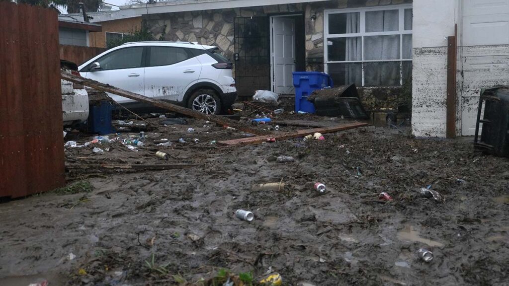
As climate change intensifies, increasing the frequency of floods, wildfires, and extreme heat, homebuyers in the United States are losing access to crucial information about the risks associated with their potential properties. In November, real estate giant Zillow removed its feature displaying climate risk data, a tool that had been available for just over a year. This decision came after the California Regional Multiple Listing Service (MLS) raised concerns about the accuracy of the flood risk models provided by First Street, the climate risk modeling company that supplies data to various real estate platforms, including Zillow.
Neil Matouka, a climate policy expert and former manager of California’s Fifth Climate Change Assessment, is working to fill this gap. He is developing a proof-of-concept plugin that aims to reintroduce climate risk data to Californians. When active, the plugin will automatically display essential information related to wildfire and flood risk, sea level rise, and exposure to extreme heat whenever a user views a property listing on Zillow.
“We don’t need perfect data,” Matouka stated. “We need publicly available, consistent information that helps people understand risk.”
The impetus for Zillow's removal of climate risk information originated from the California Regional MLS's assertion that the flood models were misleading. In a statement, the MLS emphasized, “Our goal is simply to ensure homebuyers are not being presented with information that could be misleading or unfair. We have no objection to the display of accurate climate data.” In response to these concerns, Zillow opted to remove all climate-related data, which included factors such as flood, fire, wind, heat, and air quality risks. However, the listings still include hyperlinks to First Street's data, which may be easily overlooked by users.
Despite Zillow's decision, other real estate websites like Homes.com, Redfin, and Realtor.com continue to feature First Street’s climate data. This data suggests that more properties are at flood risk than those identified by the Federal Emergency Management Agency (FEMA), which has faced its own criticism for outdated flood mapping.
“We take accuracy very seriously, and the data speaks for itself. Our models are built on transparent, peer-reviewed science and are continuously validated against real-world outcomes,” First Street commented.
Research has shown that disclosing flood risk can affect home prices negatively. According to both academic studies and Zillow's internal analysis, buyers are increasingly considering climate risk in their real estate decisions, especially in a strained market. First Street argued, “Climate risk data didn’t suddenly become inconvenient. It became harder to ignore in a stressed market.”
However, predicting climate risk on a home-by-home basis remains a challenging endeavor. For example, a property may sit right on a FEMA flood risk boundary, with one home deemed higher risk than its neighbor due to geographical variances or mapping process artifacts. Furthermore, fire risk assessments often fail to consider home-hardening measures that could significantly impact a property’s vulnerability to wildfires.
According to Chris Field, director of the Stanford Woods Institute for the Environment, the current models are better suited for outlining the broader environment of risk rather than providing precise predictions for specific properties. “The more detailed you get to be either in space or in time, the less precise your projections are,” he explained.
Matouka’s plugin is designed to communicate the overarching risks present in an area rather than provide specific property risk assessments. He believes that open access to reliable climate data is critical for empowering homebuyers to make informed decisions.
The path to improved accuracy in climate risk models hinges on transparency, according to Jesse Gourevitch, an economist at the Environmental Defense Fund. California’s unique position, with its wealth of publicly available data, makes it easier to develop tools like Matouka’s plugin, though replicating such solutions in other states may prove more difficult due to private data companies' reluctance to share their methodologies.
“A lot of these private-sector models tend not to be very transparent, and it can be difficult to understand what types of data or methodologies that they’re using,” Gourevitch noted.
Matouka’s plugin incorporates publicly available data from state and federal agencies, whose methodologies are accessible online. Experts generally agree that a combination of private and public data sources is vital for generating credible climate risk assessments, although improvements are necessary. “People who are making decisions that involve risk benefit from exposure to as many credible estimates as possible, and exposure to independent credible estimates adds a lot of extra value,” Field concluded.
Currently, Matouka’s plugin is in beta testing, and he is open to feedback as he prepares it for broader use. The beta version is available for interested users to explore.
Why Tigers and Koalas Are Forever Separated by a Mysterious Line—The Shocking Truth Revealed!

Could This Week's Big Tech Earnings Send Dow, S&P 500, and Nasdaq Plummeting? Find Out Now!

France's Shocking Social Media Ban for Minors: What Parents MUST Know to Protect Their Kids!

Supreme Court's Shocking Decision: Could Brazil's Crypto Ban Spark Election Chaos? Find Out!

Is 2028 the Deadline for Humanity? Shocking New Report Reveals What’s at Stake!

2026 Election Shockers: Who Will Lead Duplin County? You Won't Believe Their Controversial Plans!
You might also like: